
The aerial survey images can be captured by a variety of cameras, e.g. as high definition VDO or picture camera, IR camera, etc., to match the requirements. The images from the UAV come with the flight information log files for further imagery processing. Typical survey results that Centrovision delivers to the clients are as follows:

Aerial Picture Map
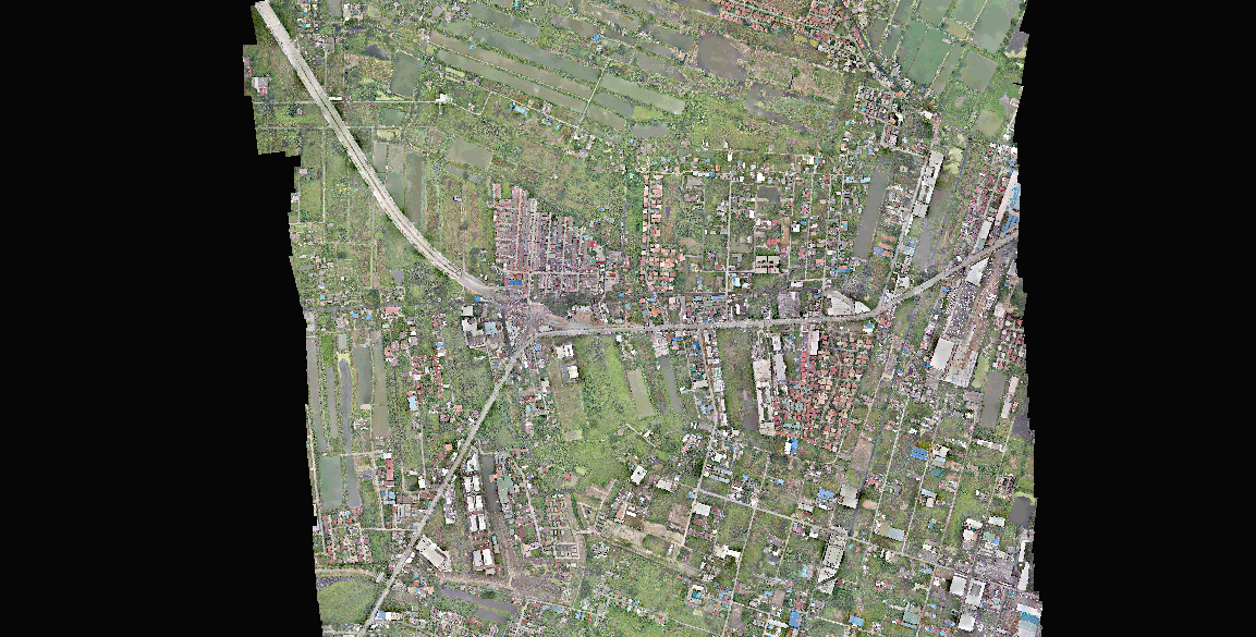
Orthophotographs* are collected and stitched together to illustrate fine details of a specified area.
*Orthophotograph is an aerial photograph or image geometrically corrected such that the scale is uniform: the photo has the same lack of distortion as a map.

Landscape Survey
จัดทำขึ้นเพื่อทำภาพแผนที่แสดงการใช้ประโยชน์ของที่ดิน

Plantation Survey
จัดทำขึ้นเพื่อบ่งบอกสภาพการณ์ของพืชในพื้นที่ โดยนำไปเป็นข้อมูลประกอบการวางแผน
Construction Survey
จัดทำขึ้นเพื่อการวางแผนการก่อสร้าง และสำรวจสภาพโดยรอบของพื้นที่ก่อสร้าง
Contour
A rough contour can be produce to give an outline understanding about the elevation in the specified area.

3-D Model
Three dimensional model can be derived from the contour to gain a better perspective of the specified area topography.

Aerial Viewer
Georeferenced* video can be captured to inform about any infrastructure of the specified area.
* Georeferencing means that the internal coordinate system of a map or aerial photo image can be related to a ground system of geographic coordinates.


In the past, Unmanned Aerial Vehicle (UAV) for large scale remote sensing was not practically viable due to the limitation of the plane, autopilot and payloads. Centrovision is able to break through those barriers by developing UAVs which are capable of long-range flying with high stability in rough weather conditions. Our planes can take sufficient payloads of suitable camera(s) and other relevant equipment as well as a world class autopilot system. Centrovision also employs state-of-the-art computer technology for image processing, which is able to produce orthophoto, picture map, contour (topography) and 3D model with relatively high resolution and accuracy.

CenAirSurvey
Benefits
Cost Effective
in comparison with same ground resolution, accuracy and timely results, Centrovision is able to provides the solutions very cost effectively.
High Resolution Images
resulting from low flight altitude and high definition camera, the ground images are very sharp and clear.
High accuracy and ortho-corrected Images
each image is tagged with flight information log file. Of which the imagery processing software can use to generate accurate positioning as well as ortho-corrected images.
Timely Information
Centrovision UAV can cover up to 2,200 Ha or some 14,000 rai per plane in a clear sky day and it will take another few days for image processing to yield accurate picture map. Thus the large-scale survey area can be obtained in a few days.
Hassle Free and Low Profile Operation
Centrovision UAVs do not need airport and produces zero emission, quiet and almost undetectable, thus resulting no nuisance to nearby residence and keeping the operation hassle free and low profile.
Versatility
Centrovision’s ability to tailor the entire system, which includes the airplanes (fixed wing or rotor types) and cameras, to meet individual requirements is one of the key success factors to provide the right solutions to our clients.
* Image Resolution

** Timely Information
